The Out Islands

The Out Islands are incredibly remote

Some found this out the hard way.

Wealthy would-be-festival-goers who were duped by the infamous Fyre Festival—a botched music festival that was planned for a private island paradise in the Exumas—found little sympathy outside their peer group when the Fyre fraud was finally revealed.

Simply put, the thought of 10,000 people flying into Exuma International Airport on an air caravan of Cessna planes over the course of one weekend is laughable. This airport only accommodates an average of 5,000 visitors each month. The waiting area is so small that on a normal busy day, visitors opt to wait across the road at Kermit’s Airport Lounge, a small bar and restaurant with picnic-style outdoor seating and an air-conditioned restaurant interior.

Lessons Learned

In their misfortune, however, are important lessons to learn about traveling to the Out Islands of The Bahamas. With a little insider’s knowledge about the Out Islands, travelers will know what to expect.

The term “Out Islands” refers to the group of islands in The Bahamas located outside of the largest cities: Nassau on New Providence and Freeport on Grand Bahama, known as the second city. The Out Islands are more remote, less developed and less densely populated. Bahamians refer to the Out Islands as the Family Islands, which is based on the premise that while the center of politics and government is in Nassau, The Bahamas is a family of islands.

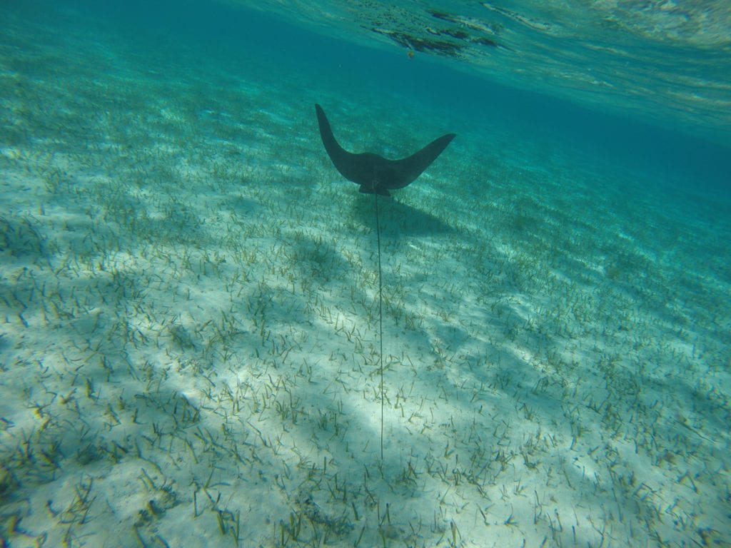
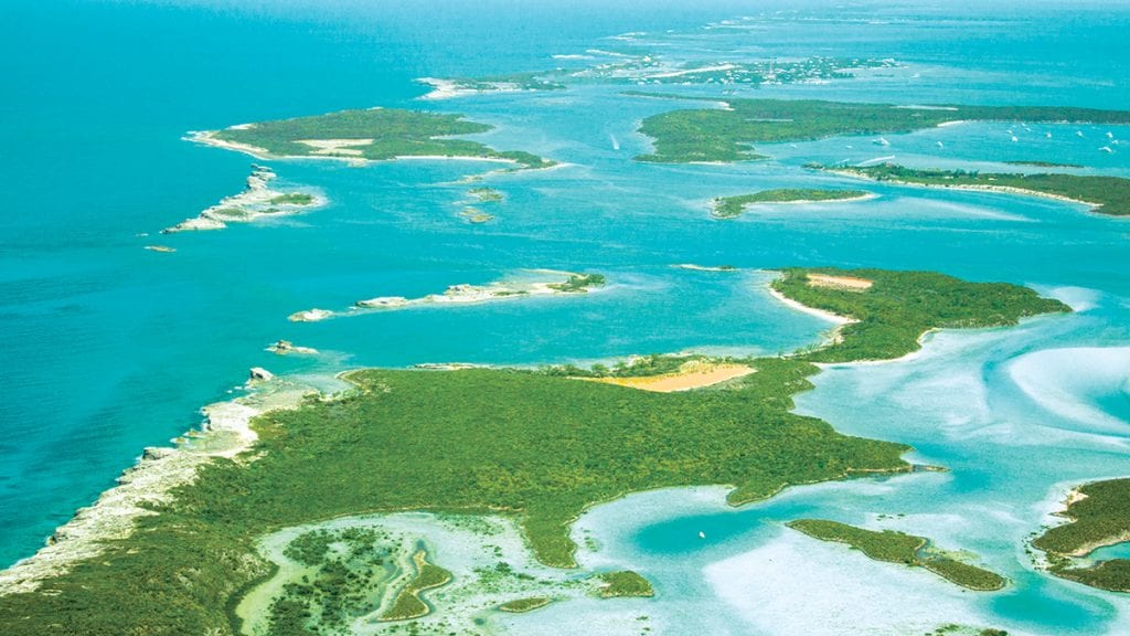
The Exumas, a small archipelago known for its plethora of islands and secluded beaches, turquoise sandbanks and aquamarine seas, is the most popular Out Island in terms of
tourist arrivals. Some 60,000 visitors travel to its shores by air and sea annually. They enjoy marine attractions, such as underwater caves, shark encounters and floating beaches that emerge at low tide as sandbars suspended in the middle of the sea.

Boaters Love the Out Islands

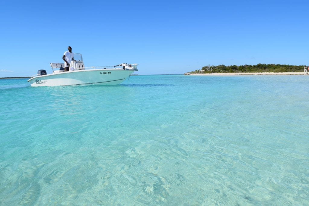
For most boaters, the primary appeal of The Bahamas is the Out Islands. The ten major seaports in the Out Islands welcomed over 91,000 visitors in 2018. This compares to just
12,635 sea arrivals in Nassau for the same year. Bimini and the Abacos are the top two Out Islands in terms of visitor arrivals by sea: Bimini, unsurprisingly, as it is the closest
Bahamian island to the U.S. with a convenient first port of entry. The Abacos, of course,  is considered the boating capital of The Bahamas.

The Abacos has a number of barrier islands that protect mainland Great Abaco from the ferocious Atlantic. The protected marine highway between the barrier islands and Great Abaco, the Sea of Abaco, is a central hub for boating. Virtually every exit survey in The Bahamas, sites visiting beaches as the number one activity. Abaco is no exception; however, fishing and island-hopping are two dominant activities also enjoyed by boaters in the Abacos, where there are vibrant boating communities on Treasure Cay, Marsh Harbour, Green Turtle Cay, and other neighboring islands.

You’re not in the city

Traffic in the Out Islands is a slow-driving car that you can’t immediately overtake. In other words, there is no traffic in the Out Islands. Basically, every Out Island has a main artery road, usually named the Queens Highway, that runs north to south across the length of the island. The cars are sparse and it’s difficult to get lost.

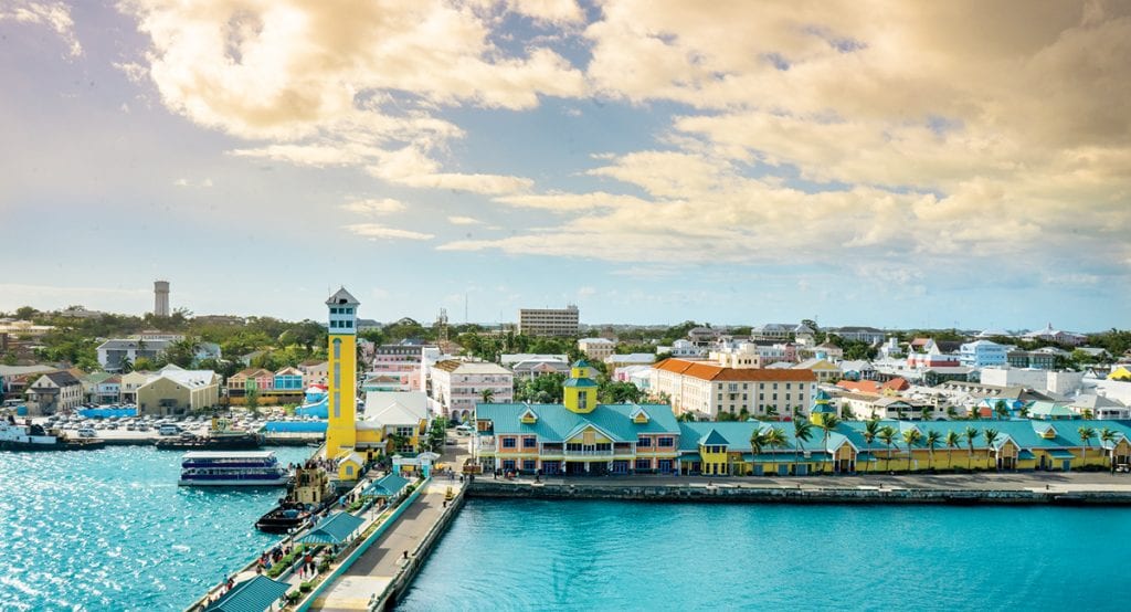
You’ll know when you’ve reached a settlement because virgin land gives way to roadside communities. Compare to Nassau’s primetime, bumper-to-bumper traffic. Without GPS, you are likely to get lost in Nassau. Nassau has a distinct city character. The Out Islands are remote enclaves where you can retreat from crowds, busyness, city lights, and noise.

Nassau has an international airport with amenities travelers expect: restaurants, bars, private lounges, shopping, and other creature comforts. Airports in the Out Islands, even the international ones, are little dives. But they are clean, safe and their technical aviation systems are top notch. However, consumer infrastructure is very limited. If you are delayed in an Out Island airport, it is likely to be frustrating because the facilities are not designed for comfort.

Most of the Out Islands are not a single island

The Bahamas is one nation, but it is a country with 700 islands and more than 2,000 rocks and cays.  The sheer number of islands is overwhelming. That’s why only 16 main islands, including Andros, Cat Island, Long Island, and Inagua, are marketed as tourist destinations. The 16 islands are main population centers with infrastructure like airports and seaports.

While the island names and groupings create simplicity, it’s important to remember that there is always more than what meets the eye. Eleuthera, for example, is one island. However, it also refers to a trio of islands including Harbour Island and Spanish Wells. The water taxi between the Three Islands Ferry Dock in North Eleuthera and Harbour Island takes only 10 minutes; however, the run from Valentine’s Marina in Harbour Island to Cape Santa Maria Marina in South Eleuthera is more than 100 miles on the ocean side and 80 miles on the banks.

Exuma (singular) usually refers to mainland Great Exuma, the largest island in the Exuma chain, but the Exumas (plural), more correctly identifies the 365 islands located in the chain. Some of them are private islands with private airstrips and many are uninhabited. All of them are comparatively rural and have light-touch development. They are charming because of their safe, close-knit communities with people living a more independent, carefree lifestyle than in the capital.

Almost all of the Out Islands, even when their names suggest one island, are themselves a cluster of islands, including Bimini, the Berry Islands, Andros, Inagua, and Acklins and Crooked Island.

By Noelle Nicolls, Southern Boating April 2019

Southern Exumas

Southern Exumas

An iconic place for beaching and boating in The Bahamas is a string of pearl-like islands —the Exumas. But, if you visit the southern Exumas, Acklins Island, Crooked Island and Long Cay in particular, you’ll find the familiar aquatic landscape more commonly associated with the Exumas to the north.

These three atoll islands encircle the Bight of Acklins, a 500-square-mile lagoon, where you can wade in the water knee-deep for thousands of feet offshore. The shallow seas encasing the islands radiate turquoise light. A tapestry of undulating white sands blankets the ocean floor, peeking out here and there to showcase a collection of elongated sandbars. The meandering coastlines are dotted with countless sandy bays, crescent-shaped coves, and mangrove nurseries. A network of tidal creeks and inlets snake through the land, and from sky high, they appear like saltwater rivers slicing cuts into the coast.

Long Crooked Acklins

Acklins Island, Crooked Island and Long Cay are truly underexplored island gems in the southern Bahamas. Unlike the Exumas, these sister islands are known more for their bonefishing and ecotourism than for their boating and physical beauty. But island-hopping in these islands will turn that perspective completely upside down. Take in the scene at the French Wells  Channel between Long Island and Crooked Island, or cruise around Turtle Sound or Lovely Bay, and the stunning picture will be abundantly clear.

The Bight of Acklins is the “Exumas of the South” when it comes to beaching and boating. Beach Hop the North Coast­ Start in Lovely Bay, where you can comb for shells on the Lovely Beach sandbar or spot iguanas on Snake Cay. Chase stingrays in Chester’s Bay or head beyond the main Atwood Harbour Beach to a cay locals call Saddleback. Saddleback Cay marks the opening of a creek that winds its way down to Gordon’s Bay. Depending on the tides, Saddleback is only connected by the beach.  On the tip of the cay is a large osprey nest. The birds stand watch over this entrance, soaring above to keep an eye on visitors.

Underexplored

Despite its array of offerings, Acklins and Crooked Island are not as accessible as other islands in The Bahamas. There are no marinas or official docking facilities, so boaters have to use the various anchorages. Commercial flights with the national airline, Bahamas Air, originate from Nassau, the capital of The Bahamas, and fly to Acklins and Crooked Island only twice per week on Wednesdays and Saturdays. Long Cay is only accessible by private boat or a ferry from Crooked Island.

­Hotels are limited to a few bonefishing lodges scattered around the Southern Exumas, including Chester’s Highway Inn, Chester’s Bonefishing Lodge, Grey’s Point Bonefish Inn, and Ivel’s Bed and Breakfast on Acklins Island. Also, Acklins only has a population of about 500 people compared with Nassau, which has about half the landmass as Acklins with a population of about 300,000. Acklins, Crooked Island and Long Cay are relatively secluded and rural. The inhabitants fend for themselves and epitomize the simplicity of island living.

There are no gourmet restaurants, although the local food is delicious. Chester’s Highway Inn serves creamy lobster chowder as its welcome meal, and it’s chock-full of flavorful, meaty goodness. There are a few local bars for entertainment. You’ll meet a charismatic (and perhaps pestering) local drunk. You’ll also meet hard-working island people who pass the time by drinking rum and gossiping.

City slickers would likely not survive in Acklins unless they were specifically looking to go off the grid. Boaters, however, with simple tastes and plans to spend their days on the water fishing, snorkeling, diving, beaching and enjoying the outdoors, would find an attractive vacation home in Acklins, Crooked Island and Long Cay.

Launch a Kayak

Atwood Harbour, Relief Bay, and Gordon’s Bay have ample bonefishing flats. But it’s also an ideal spot to kayak. These uninhabited parts of the island hardly have any civilization to speak of. Many areas are only accessible by boat, but they all have at least one inland access point to launch a kayak. They also serve as anchorages. In Atwood Harbor, you can land a dinghy on the beach and walk about two miles to Chester’s Settlement.

Spot Flamingos

If the horizon line is glowing pink, it’s not a mirage, it’s a colony of West Indian flamingos in the distance. Acklins, Crooked Island and Long Cay all have flamingos. Flamingos are The Bahamas national bird. These regal birds are skittish about visitors, but there are three reliable places to spot them in their natural habitat: Mason’s Bay and Chester’s Pond in Acklins and Flamingo Bay in Long Cay.

Bonefishing

There’s tons of fishing in the Southern Exumas, but bonefishing is the ticket. You don’t need a boat for most of the flats. Instead, you can walk off the shoreline, wading and stalking your fish. The peak fishing months are March through November as the weather is more unstable between December and February. However, fishing is a year-round pastime in the south.

In addition to these core activities, sail around the atoll or cave on Crooked Island. There are coral gardens and historic ruins, including the remnants of slave and cotton plantations. Bird Rock Lighthouse sits on the northwestern point of Crooked Island, and Castle Island Lighthouse sits off the southern tip of Acklins. Boaters can also explore the Samana Cays to the northeast and the Plana Cays to the east.

By Noelle Nichols, Southern Boating January 2019

The Path to Crooked Island

Throughout The Bahamas, there exist less-traveled paths that contain treasures around every bend. Here’s a tale: the path to Crooked Island.

Her name was Delia, a Morgan 38 with a white hull and beige canvas. That’s what I was looking for as I squinted in the afternoon sun, scanning over the crowded anchorage at Marsh Harbour in the Abacos. I was joining up with a crew heading to Crooked Island, but now I was searching for my ride. Oh man, I groused, almost all the boats here have a white hull and look like a Morgan 38. How am I going to find this thing?

My American cell phone was useless; there was nothing to do but let the taxi driver go and hope someone spotted me from the boat. Somehow the gravitas of my presence at Union Jack dock was enough to attract the keen eyes of boat owner Coy McDonald, who dispatched the dinghy forthwith to fetch me.

After introductions and a cold drink, Coy discussed the intended itinerary as his first mate and wife, Christina, whipped up one of the many excellent meals we would enjoy on board. “We’ll run down the Sea of Abaco,” he told us, “then jump offshore and run straight to Crooked Island” (part of the Bight of Acklins). Erik, an itinerant sailor from Manjack Cay, and Niki, a travel blogger, rounded out the crew.

Sundays in The Bahamas are very quiet. The only things usually open are churches and beaches, but lucky for us, Maxwell’s Supermarket was open for business and fully stocked. This would be the last grocery store in our path, so we jammed two shopping carts full of provisions into the overloaded dinghy and headed back to Delia. With a full larder, we weighed anchor and got underway at 1300. Coy gave a safety briefing while I punched waypoints into the GPS.

Heading south, I learned of some of the issues Delia had faced so far on this voyage. There were fuel and alternator problems, and the single-sideband and autopilot were not functioning, but this was nothing we couldn’t overcome. While at Little Harbour, Coy spent several hours on the phone talking with a marine tech in Florida who patiently guided us through a checklist of tests and, somehow, the alternator returned to life. The voyage to Crooked Island was saved.

After an overnight passage along the spine of Eleuthera, we cleared Bonefish Point on Cat Island and decided to drop the hook in New Bight Settlement to refill the jerry jugs with diesel. It’s a treat every time I sail here. This time, we discovered that residents had built a free shower house for visiting yachts. (If you go, it’s a turquoise-colored building on the north side of the anchorage.)

In the cockpit that evening, Christina served up another delightful repast featuring the tuna we caught that morning and Mount Gay cocktails. Ah, the sublimity of the moment; we toasted the flower moon as it glowed above the monastery on Mount Alvernia—this is why we sail.

The next morning, Erik and I hitched a ride and returned with 10 gallons of diesel. We got underway and before long, we rounded Hawk’s Nest Point and set course for Crooked Island. The bottom dropped out of the depth sounder and the trades filled in from the east.

I’m sure you’ve heard about the green flash. I always thought it a myth, a chimera created by whimsical sailors who want to make the ocean sound more appealing. But I can tell you now that it’s real. I saw it that night, and I have four witnesses.

Offshore passages are very exciting but tough on the body. It’s difficult to get proper sleep. I scheduled myself for the middle watch (0000-0400) and should have taken a nap that evening beforehand, but there was too much going on and before I knew it, I was at the wheel with everyone else snoring below. Puffy clouds cloaked the moon. The wind freshened, the boat heeled.

I was simultaneously exhausted and exhilarated as Delia galloped along past the darkened shapes of Conception Island and Rum Cay. At 0930, right on cue, the lighthouse on Bird Rock popped over the bright horizon. By noon we were turning into the wind and the water went from purple to blue, to turquoise, then white. Down splashed the anchor, and the crew made ready for shore leave. Onward to Crooked Island.

From the moment the dinghy landed in Landrail Point Settlement we could see that all was not right. Hurricane Joaquin had really torn the place up in 2015; ruined buildings were everywhere. There were no people. It had the eerie feel of a war zone. But in a moment, everything changed as a truck sped down the dusty road. The smiling driver called to our charter host, “Coy! We heard you were coming!” The two embraced.

Another truck arrived, and the occupants jumped out to welcome us to their home. We climbed in and were spirited off to the cultural center of the island, Gibson’s Restaurant #2, run by matriarch Willie Gibson who had anticipated our arrival and planned a nice dinner for us. Why #2, you ask? Restaurant #1 was destroyed in Hurricane Joaquin. We returned at 1930 and feasted on the best meal I have ever experienced in The Bahamas: lobster tail, conch salad, taters, and cheesecake. I waited for the check which never came. Coy whispered to me, “This is how these people are. We’re not customers, we’re family.”

After breakfast, Woody, a fishing friend of Coy’s, came by on his Boston Whaler with his crew, Andy and Henry. They offered to let me ride along for the morning trip and I jumped at the opportunity. Out we went, back into the purple water near Bird Rock Lighthouse, an abandoned brick edifice constructed by the British in 1876. They pulled three traps that contain about 50 pounds of fish. We doubled back to the reefs, and I surprised them all when I jumped right in, grabbed the boarding ladder and dragged along for the ride.

Taking fish in The Bahamas must be done sans scuba gear, so Woody and Henry swam in lazy circles till they spotted a conch or spiny lobster, and then the magic began. They took a deep breath, slowly equalized their eardrums and gracefully kicked their way to the bottom, maybe 40 feet down, to retrieve something edible. And so it went all morning, up and down, until the Whaler was so full of shellfish that she listed. I could only act as a spotter, watching in admiration as these masters of the reef did their work.

At the damaged airport the next morning, Willie and many of the island’s residents helped push the plane out onto the runway and bid me a good trip home. They have a tough life here, yet they are welcoming, generous and kind. A perfect example of the amazing people you meet when you sail off the beaten path.

By Robert Beringer, Southern Boating May 2018

The magic of Eleuthera

Long-time resident of Governor’s Harbour Katie Black Frost is the author of Eleuthera, a beautiful work about the island with photographs from Marc Coeffic and Harry Paungger.

Eleuthera has a long, fascinating history starting with the arrival of the Eleutheran Adventurers—a group of English Puritans and religious Independents—in the mid-17th century. The island is known for its livestock and agriculture—eat an Eleutheran pineapple in season, and you will not want to leave. With more than 200 miles of coast and miles of pink sand beaches, Eleuthera is a gift to fishermen and tourists. On her website, Frost invites readers to “Come immerse yourself in Eleuthera… lose yourself in her magic.” The book is available online at eleutherabook.com, at the Haynes Library or at Tippy’s/Pineapple Fields’ gift shop in Governor’s Harbour. Read the book and feel the magic of this island for yourself.

Birds of a feather
What better way for a birder to get around than by boat? Birding can be a family activity or a full-on academic profession, and The Bahamas is one of the world’s great places to see birds.

The repopulation of the flamingos in Great Inagua is hailed as a conservation success story. Other birds like the Bahamas parrot have also been saved, and the effort continues. Birding is constantly growing in popularity throughout The Bahamas, and the National Audubon Society has recently trained 80 Bahamian bird guides.

The Bahamian government has designated The Jolters north of Andros as a protected area. Hundreds of migratory piping plovers are now seen there every winter. The Jolters has an anchorage that can be reached with a 4′ draft on the high tide. You can also anchor outside Morgan’s Bluff and run out in your tender.

Birding tours are available throughout the islands and most have websites. Carolyn Wardle (bahamasoutdoors.com, 242-362-1574 or 457-0329) leads the Bahamas National Trust Bird Club, and her organization Bahamas Outdoors has run birding and nature tours for many years. Contact Wardle, who has worked throughout the islands and has innumerable contacts, for more information.

Yet you don’t have to wait for a guide to get started. Just grab your binoculars, camera, bird book, and go for a walk or get in your dinghy to cruise the mangroves. A recent newcomer, Linda Cooper, in West End, Grand Bahama, identified more than 130 species in her first year alone.

Rum Cay, Crooked Island, Acklins
Electricity and communications have been reestablished in these islands that were devastated by Hurricane Joaquin, though rebuilding will continue for many months. The citizens of Rum Cay have scheduled their annual homecoming for February 26th—try and make it down there for the event to provide moral support and help the hurting local economy. To find out more information and how to help call Bobby Little at (242) 525-0184. Homecomings are great occasions for relatives and friends to reunite and an opportunity to welcome new friends.

Reach down to the anchorage north of Landrail Point from Rum Cay and if you need help with anything, go ashore and ask for Willie Gibson or Michael Carroll. Cruise east from Landrail to Lovely Bay, which has an anchorage inside the reef or go on to Atwood Harbour. This is a natural cruise track for boats headed for the Turks and Caicos, but it is easy enough to cruise to Crooked-Acklins and return downwind to Clarence Town, Long Island. The citizens of all these islands love visitors, and anything you can do to return the hospitality they have extended throughout the years will be much appreciated.

Little Harbour, Abaco
Little Harbour is a harbor with exceptional charm. The Johnston family, winter residents and yachtsmen provide alluring art, good fellowship and the must-go-to Pete’s Pub Beach Bar. Those entertaining a visit would do well to read Randolph Johnson’s autobiographical Artist on his Island: a Study in Self Reliance and check out petespub.com for general information.

There is now controversy over a proposed new marina in the harbor that could use up some of the limited mooring space, put added pressure on the environment and change the ambience. It’s the age-old tension between developers, environmentalists and those who want to protect a way of life. Friends of the Environment is monitoring the process and will surely act if there is a serious threat of long term environmental impact, but change may well come to Little Harbour, so the time to visit is now.

Old Bahamas photos

“Tee Time” courtesy of Bahamas Country Club Golf Tournament. Photo: oldbahamas.com

If Bahamian history piques your interest go to oldbahamas.com, where there’s a large archive of historical Bahamian photographs. The images range from the sponge fishery to colonial architecture and the development of Grand Bahama in the 1950s. The website is instructive and a lot of fun.

Navigation notes:
Northwest Light has finally been replaced. This is an important aid to navigation for those cruising from Cat Cay and Bimini to Chub Cay and Nassau. The light, however, has been reported out, so don’t depend on the marker at night—find it with your radar.


by Stephen Connett  – Southern Boating Magazine, February 2016

Exit mobile version