Southern Exumas

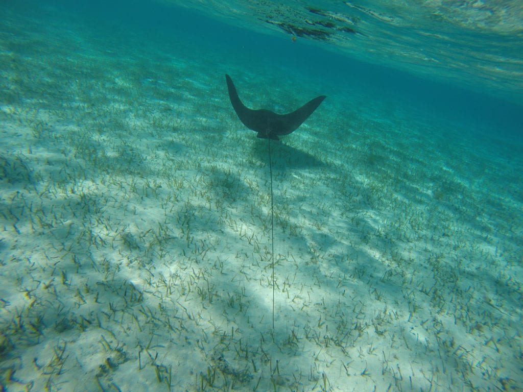
Southern Exumas

An iconic place for beaching and boating in The Bahamas is a string of pearl-like islands —the Exumas. But, if you visit the southern Exumas, Acklins Island, Crooked Island and Long Cay in particular, you’ll find the familiar aquatic landscape more commonly associated with the Exumas to the north.

These three atoll islands encircle the Bight of Acklins, a 500-square-mile lagoon, where you can wade in the water knee-deep for thousands of feet offshore. The shallow seas encasing the islands radiate turquoise light. A tapestry of undulating white sands blankets the ocean floor, peeking out here and there to showcase a collection of elongated sandbars. The meandering coastlines are dotted with countless sandy bays, crescent-shaped coves, and mangrove nurseries. A network of tidal creeks and inlets snake through the land, and from sky high, they appear like saltwater rivers slicing cuts into the coast.

Long Crooked Acklins

Acklins Island, Crooked Island and Long Cay are truly underexplored island gems in the southern Bahamas. Unlike the Exumas, these sister islands are known more for their bonefishing and ecotourism than for their boating and physical beauty. But island-hopping in these islands will turn that perspective completely upside down. Take in the scene at the French Wells  Channel between Long Island and Crooked Island, or cruise around Turtle Sound or Lovely Bay, and the stunning picture will be abundantly clear.

The Bight of Acklins is the “Exumas of the South” when it comes to beaching and boating. Beach Hop the North Coast­ Start in Lovely Bay, where you can comb for shells on the Lovely Beach sandbar or spot iguanas on Snake Cay. Chase stingrays in Chester’s Bay or head beyond the main Atwood Harbour Beach to a cay locals call Saddleback. Saddleback Cay marks the opening of a creek that winds its way down to Gordon’s Bay. Depending on the tides, Saddleback is only connected by the beach.  On the tip of the cay is a large osprey nest. The birds stand watch over this entrance, soaring above to keep an eye on visitors.

Underexplored

Despite its array of offerings, Acklins and Crooked Island are not as accessible as other islands in The Bahamas. There are no marinas or official docking facilities, so boaters have to use the various anchorages. Commercial flights with the national airline, Bahamas Air, originate from Nassau, the capital of The Bahamas, and fly to Acklins and Crooked Island only twice per week on Wednesdays and Saturdays. Long Cay is only accessible by private boat or a ferry from Crooked Island.

­Hotels are limited to a few bonefishing lodges scattered around the Southern Exumas, including Chester’s Highway Inn, Chester’s Bonefishing Lodge, Grey’s Point Bonefish Inn, and Ivel’s Bed and Breakfast on Acklins Island. Also, Acklins only has a population of about 500 people compared with Nassau, which has about half the landmass as Acklins with a population of about 300,000. Acklins, Crooked Island and Long Cay are relatively secluded and rural. The inhabitants fend for themselves and epitomize the simplicity of island living.

There are no gourmet restaurants, although the local food is delicious. Chester’s Highway Inn serves creamy lobster chowder as its welcome meal, and it’s chock-full of flavorful, meaty goodness. There are a few local bars for entertainment. You’ll meet a charismatic (and perhaps pestering) local drunk. You’ll also meet hard-working island people who pass the time by drinking rum and gossiping.

City slickers would likely not survive in Acklins unless they were specifically looking to go off the grid. Boaters, however, with simple tastes and plans to spend their days on the water fishing, snorkeling, diving, beaching and enjoying the outdoors, would find an attractive vacation home in Acklins, Crooked Island and Long Cay.

Launch a Kayak

Atwood Harbour, Relief Bay, and Gordon’s Bay have ample bonefishing flats. But it’s also an ideal spot to kayak. These uninhabited parts of the island hardly have any civilization to speak of. Many areas are only accessible by boat, but they all have at least one inland access point to launch a kayak. They also serve as anchorages. In Atwood Harbor, you can land a dinghy on the beach and walk about two miles to Chester’s Settlement.

Spot Flamingos

If the horizon line is glowing pink, it’s not a mirage, it’s a colony of West Indian flamingos in the distance. Acklins, Crooked Island and Long Cay all have flamingos. Flamingos are The Bahamas national bird. These regal birds are skittish about visitors, but there are three reliable places to spot them in their natural habitat: Mason’s Bay and Chester’s Pond in Acklins and Flamingo Bay in Long Cay.

Bonefishing

There’s tons of fishing in the Southern Exumas, but bonefishing is the ticket. You don’t need a boat for most of the flats. Instead, you can walk off the shoreline, wading and stalking your fish. The peak fishing months are March through November as the weather is more unstable between December and February. However, fishing is a year-round pastime in the south.

In addition to these core activities, sail around the atoll or cave on Crooked Island. There are coral gardens and historic ruins, including the remnants of slave and cotton plantations. Bird Rock Lighthouse sits on the northwestern point of Crooked Island, and Castle Island Lighthouse sits off the southern tip of Acklins. Boaters can also explore the Samana Cays to the northeast and the Plana Cays to the east.

By Noelle Nichols, Southern Boating January 2019

Hurricane Matthew Updates, Snake Cay and other Bahamian Updates

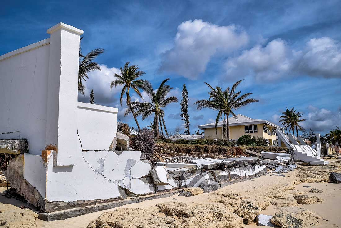
On October 6th and 7th, 2016, Hurricane Matthew roared northward through the central Bahamas leaving a trail of damage behind.

The storm was at Category 4 strength for much of that time, with wind speeds upwards of 150 mph near the eye. Thankfully, no lives were lost, although some areas suffered extreme damage to homes and businesses. Recovery and rebuilding efforts began immediately as relief poured in from local and U.S. sources. The worst impacts were in Nassau and New Providence Island, Andros, and Grand Bahama’s West End southern shore. We surveyed a number of sources within the Bahamian boating community to get an idea of the impact on marine infrastructure, particularly the marinas. Fortunately, damage on the water side was generally modest and repairs are moving quickly at press time. Bimini, Great Abaco and the Sea of Abaco, Exumas, and the Out Islands of Long, Cat and Eleuthera are in great shape and should not present any problems. The southeast Bahamas took a close brush from Matthew early but are ready for transients.

Nassau and the rest of New Providence was hit hard, but the marinas are all back in operation and receiving transient boats. The small communities on Andros and West End, Grand Bahama, took the brunt of the storm and will likely be the last to come fully online. At this writing, nearly all of the marinas in these areas are up and running, with a few limitations. But even where the marinas escaped relatively unharmed, nearby businesses and the residences of employees may have sustained damage, so supplies and services may still be limited. We suggest you call ahead to ensure you will find what you need. Bahamians are tough, resourceful and are working hard to restore their own lives. More than likely, by the time you read this they will be ready and anxious to welcome you to their beautiful country.

Snake Cay

In the highly developed area around the Sea of Abaco, there is an oasis of natural quiet that is easily accessible but still seems an ocean away from the resorts of the nearby cays. Snake Cay, about six nautical miles south of Marsh Harbor and Elbow Cay in the Sea of Abaco, is just off the eastern shore of Great Abaco Island. It is uninhabited except for the ruins of development long since abandoned. Exploring ashore is an eerie experience. A major paper company once centered their Abaco lumbering operation here, and you can see the decaying commercial dock and remains of the land-side facilities.

In settled weather, you can anchor on the north side of the easternmost hook of the cay. Holding is a bit suspect, with a thin layer of sand over marl. Set your anchor well and check the set by swimming the anchor. If strong winds are forecast, it is best to move on.

The real reason to visit here is the wonderful dinghy expedition possible from here to the south. Rounding the easterly hook of Snake Cay, turn west and proceed westerly in the deep water channel between Snake and Deep Sea Cays, then turn south on the west side of Deep Sea Cay. From here, you can run south for miles, with a line of small, uninhabited cays to your east and Great Abaco to the west. Depths are generally 1 to 3 feet. Proceed slowly and you are sure to see many turtles, starfish and other marine life in the shallows. The main island is largely free of development, although you will see some intriguing ruins here, too. This is beautiful, unspoiled Bahamas, much as it “used to be”, yet close to some of the most developed parts of the islands.

Island Roots Heritage Festival

Green Turtle Cay hosts the Annual Island Roots Heritage Festival in early May in the village of New Plymouth. Founded in the late 1700s, New Plymouth was originally rooted in the traditions of American Loyalists who fled the newly independent United States after the revolution. But the hardships of agriculture in the islands eventually led many to flee back to the U.S., particularly to Key West, where they were instrumental in the early development of that community. These ties continue today between the sister cities.

The Roots Festival was first held in 1977 on both islands to celebrate their ties and revived on Green Turtle in 2004. Now held annually, the festival runs this year from May 19-21. The festivities include local foods served on the festival site, a Junkanoo Rush, children’s activities including a Maypole, and performances by the Royal Bahamian Defense Force Marching Band and local bands. This is an authentic Bahamian experience well worth a visit.

Navigation Update

Little is yet reported in the aftermath of Hurricane Matthew, but it is safe to assume that some navigation aids and channels have been affected by the storm. Palm Cay reports some marks off station, but repairs will be quickly completed. Other marina channels will likely be similar. The few government marks will probably receive little attention from the authorities in the short term as the focus remains on land-side recovery efforts. As always in The Bahamas, stay vigilant and travel slowly, carefully and in good conditions.

By Rex Noel, Southern Boating Magazine January 2017

Exit mobile version