


It is estimated that 95 percent of the earth’s oceans remain unexplored. No wonder since the ocean covers 140 million square miles of the earth’s surface with an average depth of 12,000 feet.
The ocean floor’s deepest point is 36,000 feet below the water’s surface in the western Pacific Ocean and is called the Challenger Deep section of the Mariana Trench. It is extremely inhospitable down there. There’s virtually no light, water temperatures are near freezing and the pressure is a crushing 1,000 times what it is at sea level. But, in order to manage and protect ocean resources, we must learn what’s far below the surface.
The U.S. government agency that does much of the basic research for both the atmosphere and the oceans is the National Oceanic and Atmospheric Administration (NOAA) under the Department of Commerce. One branch of NOAA is the Office of Ocean Exploration and Research (OER), which is touted as “the only federal organization dedicated to exploring the unknown reaches of our ocean”. To support these endeavors, the Office of Marine and Aviation Operations (OMAO) supplies the ships and aircraft needed as well as the personnel to run them (omao.noaa.gov/).


OMAO is staffed by civilians and also has an enlisted contingent. The NOAA Commissioned Officer Corps—simply known as NOAA Corps—is one of the nation’s seven uniformed services. Prior to admission, candidates must possess a baccalaureate degree preferably in math, science or engineering. Basic training in seamanship is held in conjunction with the Coast Guard’s officer training program. After successful basic training and commissioning, officers receive their first ship assignment based on their qualifications and service needs. The 321 officers of the NOAA Corps are seamen and scientists and support NOAA’s wide variety of oceanic research efforts.
One of the primary duties of NOAA Corps officers is to operate NOAA’s research aircraft and ships. NOAA has nine manned aircraft which are stationed at MacDill AFB in Tampa, Florida. Two Lockheed WP-3D aircraft are designated “Hurricane Hunters” and fly into these great storms to gather vital data. Other smaller aircraft fly a variety of scientific missions across the country. NOAA also has drones it uses for monitoring wildlife.
NOAA has a fleet of 16 ships, the nation’s largest fleet of oceanographic research and survey ships, which are administered by the OMAO. These ships are engaged in fisheries surveys, hydrographic surveys and oceanographic research. Operations centers are located in Norfolk, Virginia, Newport, Oregon, and Honolulu, Hawaii. The ships are run by NOAA Corps officers with some civilian seamen completing the crew.
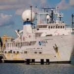
The pride of the NOAA fleet is the NOAA ship Okeanos Explorer, dubbed “America’s ship for ocean exploration”. A former U.S. Navy ship, Okeanos was refitted for oceanographic exploration and commissioned in 2008. The name was actually the winning entry in NOAA’s nationwide ship-naming contest and according to Greek cosmology, Okeanos was the river/ocean that encircled the world. The 224-foot Okeanos Explorer has a crew of 27 and typically sails with 19 scientists on board. These are OER research missions, and NOAA wants to involve as many experts as possible. Interested scientists can apply for the limited number of positions actually on board the ship. But much of the expert input on missions comes from teams of scientists at various Exploration Command Centers with the Inner Space Center at the University of Rhode Island Bay Campus being the primary one.
Okeanos Explorer is equipped with a high-bandwidth satellite communications system (the large satellite dome on the ship) which allows rapid data transmission. Scientists on shore can then have “telepresence”, which enables them to view Okeanos’ findings almost instantaneously and communicate back to the ship as necessary while helping to direct the mission.
Exploration missions often take the vessel to remote ocean areas. With high-powered sonar equipment, a major objective of the research cruises is to map previously unknown sections of the sea floor. For a closer examination of deep water sites, Okeanos has two remotely operated vehicles (ROVs), Deep Discoverer (D2) and its sister vehicle Seirios. With 20 LED lights and 9 video cameras, the ROVs can plunge to depths of nearly four miles and send back high-definition video, which is live-streamed to scientists on the ship and back on shore.
In 2016, the Okeanos Explorer explored the Northern Marianas Islands, Guam and the Marianas Trench Marine National Monument. Scientists on board and connected remotely could view previously unexplored areas of the seafloor. They observed a number of new animal species and unusual geological features. This year, the Okeanos Explorer will again be involved with Project CAPSTONE, a multi-year scientific investigation of deep-water, U.S.-protected marine areas in the central and western Pacific Ocean. These include national marine sanctuaries and marine national monuments, the underwater equivalents of national parks. Again, the goal will be undersea mapping and further explorations of biological and geological features with the ROVs.
When a mission is ongoing, the video is live streamed and broadcast through standard Internet connections.
If you’d like take part in an ongoing mission, go to the NOAA Ocean Explorer website oceanexplorer.noaa.gov. The live video feeds on the last mission generated a record-breaking 3.1 million views over the course of the expedition.
— By Ed Brotak, Southern Boating Magazine March 2017