Hurricane amnesia

Hurricane season is once again upon us and technically runs from June 1st through November 30th. NOAA’s Climate Prediction Center expects a near-normal season, however, they also warn that current and changing climate signals make predicting this season exceptionally challenging. History shows that our currently dissipating El Niño patterns could potentially lead to the hurricane-friendly conditions of La Niña. “This is a more challenging hurricane season outlook than most because it’s difficult to determine whether there will be reinforcing or competing climate influences on tropical storm development,” explains NOAA’s Climate Prediction Center lead seasonal hurricane forecaster, Gerry Bell, Ph.D. “However, a near-normal prediction for this season suggests we could see more hurricane activity than we’ve seen in the last three years, which were below normal.

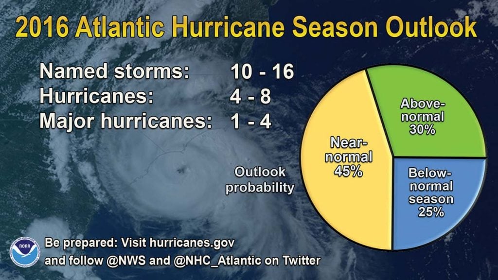
Here’s the breakdown of NOAA’s 2016 predictions:

–70 percent likelihood of 10-16 named storms (winds of 39 mph or higher)
–Of the named storms, 4-8 could become hurricanes (winds of 74 mph or higher)
–Of the hurricanes, 1-4 could become major hurricanes (Category 3, 4 or 5, with winds of 111 mph and higher)

One thing is true: It’s been more than 10 years since a hurricane has hit the southeast seaboard, so any 2016 activity could cause more damage than anticipated since communities may not be prepared for a normal season. Many southeast residences seem to have some kind of “hurricane amnesia” due to the lack of hurricanes for so many years, which is particularly concerning. According to NPR member station WJCT reporter Ryan Benk, “A [AAA] survey shows nearly half of Floridians are not actively preparing for hurricanes. And less than a quarter said they won’t evacuate, even if told to.” Those residing along or close to the coast, a population that has grown by nearly 50 percent in the last 40 years, are especially vulnerable to risks posed by hurricanes and storms.
And it’s even more challenging to forecast this season’s progression and potential impact because of La Niña’s unpredictable behavior. “There’s even more information now strongly suggesting that there’s at least a 75-80 percent chance that we will go into a La Niña pattern,” says AccuWeather Atlantic hurricane expert, Dan Kottlowski. “Historically, some hurricane seasons that have followed a transition from El Niño to La Niña have been very active. It’s possible we could flip from one extreme to the other, from below-normal seasons the past three years to an above-normal year in 2016.” If La Niña takes hold this month, it would most likely last through December.

Changes in global atmospheric circulation patterns supplement La Niña and are responsible for weather extremes in certain spots around the world. These weather extremes are routinely contrary to those associated with El Niño. Steve Graham of NASA characterizes La Niña: “These patterns result from colder than normal ocean temperatures inhibiting the formation of rain-producing clouds over the eastern equatorial Pacific region while at the same time enhancing rainfall over the western equatorial Pacific region (Indonesia, Malaysia and northern Australia). These patterns affect the position and intensity (weakening) of jet streams and the behavior of storms outside of the tropics in both the Northern and Southern hemispheres.”

By Alana Schindel, Southern Boating Magazine August 2016

Island life and tings

The Bahamas National Trust installed new signs around Conception Island to help cruisers enjoy the island, stay safe and respect the wildlife. The three moorings in West Bay have been reset and inspected. Boats over 100 feet are strongly encouraged to use these moorings; the southernmost mooring is a 3,000-pound Danforth for vessels up to 200 feet.

Sea Turtle Network

Sea turtle nesting season runs roughly from April to September. Reports of nesting activity are especially important in The Bahamas because there are so many nesting beaches scattered throughout the islands and only a few people regularly monitor them. The Department of Marine Resources has partnered with several non-governmental organizations (NGO) to form the Sea Turtle Network, the purpose of which is to reduce the illegal harvest of sea turtles that continues despite the complete ban in 2009. The Network also provides an important means of disseminating information and receiving important sea turtle observations. All cruisers are asked to report sightings of mating or nesting turtles, injured turtles, turtles found with tags, and any violations of the ban on the harvest of turtles. Reports can be made on Facebook: Bahamas Sea Turtle Network.

The Island School

Parents and grandparents interested in a rewarding experience for high school students should visit the Island School in South Eleuthera. The school and its partner, the Cape Eleuthera Institute, are located within walking distance of the Cape Eleuthera Marina.
Founded by Chris Maxey, the Island School offers full semester programs for about 50 students and offers special scholarships for Bahamians. The organization also runs a middle school in Deep Creek for local children. Spend time investigating the school’s extraordinary opportunities at islandschool.org.
The Cape Eleuthera Institute is a research facility where senior scientists conduct important oceanographic research and involve the Island School students in their projects, including ongoing studies of sharks, rays, sea turtles, lionfish, conch, and bonefish.

Left to right: Maria Cartwright, Molly Dean and Hermie Cartwright talkin’ Bahamian at the Outer Edge in Clarence Town

Talkin’ Bahamian

The Bahamas’ linguistic treasures are part of a rich culture. Here are a few of our island-lingo favorites we’ve learned over the years:
• Day clean: first light, dawn
• Me-one/you-one: by myself. “Who sailed here with you?” “Nobody. Just me-one.”
• I ain’ know, you know: answer to any question with an unknown answer.
• God spare life: answer to remarks like “See you tomorrow.”
• Done reach: has arrived, “The mailboat done reach.”
• One time ago: sometime in the past
• Tief: steal, “Someone done tief ma boat last night.”
• Owned: used with the name of the owner, “That Pam-owned car.”
• Next: another, “You want a next beer?”
• Tingum: all-purpose designation of an object the listener is supposed to know. “Fetch me another tingum.”
More Talkin’ Bahamian by Patricia Glinton-Meicholas has an excellent collection of words and phrases with good explanations of meanings and usage. Glinton-Meicholas’ How to Be a True-True Bahamian explains much of the context of these gems.

Stolen dinghies

Dinghy theft continues to rise throughout The Bahamas. There is no absolute way to prevent your dinghy from being stolen, but basic seaman’s preparedness may surely help especially as the season of thunderstorms and hurricanes is upon us. At the end of the day’s activities it is good practice to secure the boat for the night and ensure that all equipment is stowed, anchor is holding, dinghy is on deck, and so on. Be ready to react quickly to surprises that may come in the night. If you tow a larger center console boat, invest in an alarm/tracking system such as the SeaTrax II from AtlasTrax (atlastrax.com). To report theft and other crimes to the Bahamian Police, dial 911 or 919.

Dean’s Blue Hole

Dean’s Blue Hole just north of Clarence Town, Long Island, is one of the most exciting natural features in The Bahamas and is now a major location for freediving training and competition. At the annual Vertical Blue competition on Saturday, April 30th, William Trubridge broke the world record in the free immersion category of freediving. More incredible is that on Monday he went down again and added another 2 meters to his record; he reached 124 meters on a single breath lasting 4 minutes 34 seconds.
NOTE: Freediving to extraordinary depths is dangerous and should not be practiced without considerable instruction and extensive safety precautions. verticalblue.net

Navigation and safety

As everyone knows we are now well into hurricane season and the season of severe thunderstorms and water spouts. Be extra careful when selecting your anchorages as sudden squalls with shifting winds can ruin more than a good night’s sleep. Choose marinas that have good protection, always keep a short list of hurricane holes on hand, and make sure that you pay close attention to forecasts to access one of these holes in plenty of time if need be. Be sure to call these protected marinas well in advance as many marinas do not allow boats at their docks if there is a hurricane threat.
Remember how much trouble it was for meteorologists to predict Hurricane Joaquin last year? That hurricane was expected to be a category 1-2 but quickly became a category 3-5 and caused as much or more devastation than many memorable hurricanes. As the English proverb goes, “Prepare for the worst and hope for the best.”

By Stephen Connett, Southern Boating Magazine July 2016

Hurricane Season in The Bahamas

Hurricane season is upon us again, but summer and early fall are great times to cruise in The Bahamas as long as you have a good hurricane strategy. (Southern Boating readers know they need a hurricane strategy any time they’re in the hurricane zone no matter where they’re cruising.) If you look carefully at the charts and read the yachting guides you will discover that there are some excellent hurricane holes throughout the north and central islands. With good planning and a close eye on the weather forecasts you can keep yourself within reach of one of these harbors and ensure you’ll be securely moored in plenty of time. Make sure that space is available in your haven of choice and that your tanks are always topped off. The choices will depend on the size and draft of your vessel, where you want to cruise and whether you plan to stay on board during the storm.

Generally you want to choose harbors that are enclosed and small enough to have little fetch. It is also good to be tucked in behind some land and not just a breakwater. If you plan to stay at anchor make very sure that the holding is perfect. A few good choices are:

• Grand Bahama: Bradford Marine in Freeport and Port Lucaya Marina in Lucaya,

• Abacos: Baker’s Bay Marina

• Berry Islands: Great Harbour Cay and Chub Cay

• North Eleuthera: Spanish Wells Yacht Haven

• Nassau: Atlantis and Hurricane Hole

• Cat Island: Hawksnest Marina

• Exumas: Compass Cay Marina and Crab Cay

The southern islands have very few natural harbors. Fast powerboats can cruise these islands with greater safety because they can run back to Hawksnest or down to the Turks and Caicos in a few hours.

If you are new in The Bahamas local knowledge is strongly advised. Inexperienced cruisers will quickly learn that Bahamians have a very healthy respect for hurricanes and are more than willing to help anyone on the water.

Dancing with Dolphin in Conception

Be sure that you have communications systems on board that will provide you with up-to-date hurricane warnings and tracking. The Miami Hurricane Center (nhc.noaa.gov) is available on the Internet, and Chris Parker’s Marine Weather Center is available by email or single side band (mwxc.com). Be extra careful to maintain your float plan with a reliable friend or relative. We also suggest daily communications with at least one other boat cruising in your area.

San Salvador

San Salvador, the “Living Jewel” of The Bahamas, is a lovely destination with good facilities and some of the most abundant wildlife in the islands. Scuba divers swim with beautiful coral, reef fish, turtles, and sharks all along the southwestern shore. Birders find a variety of land and sea birds—Birds of San Salvador, Bahamas by R. Hays Cummins et al. is available from Kindle—and sport fishermen troll for pelagic fish on “The Hump” off the north end of the island. Bonefishermen work the flats in Pigeon Creek, and students and scientists are in residence at the Gerace Research Centre (geraceresearchcentre.com) year-round to study the island’s flora and fauna and geology. Historians still like to argue the evidence that the island was the place that Columbus first came ashore in the New World.

Best of all, the people of San Salvador know how fortunate they are and have worked relentlessly to preserve the island’s environment. For the last 10 years citizens have worked with the Bahamas National Trust, BREEF, the Gerace Research Centre, the Nature Conservancy, and the Bahamian government to achieve permanent protection for important habitats on the island and in its coastal waters.

At a ceremony in Cockburn on April 23rd the Deputy Prime Minister, Phillip “Brave” Davis, announced the establishment of five new national parks in San Salvador. The parks will be managed by the Bahamas National Trust. Most important to cruisers are the protected area on the west side, Graham’s Harbour and Pigeon Creek. These parks are part of the growing number of no-take marine protected areas that will protect at least 20 percent of Bahamian near-coastal waters by 2020 as part of the Caribbean Challenge.


By Stephen Connett, Southern Boating Magazine July, 2015

Exit mobile version