

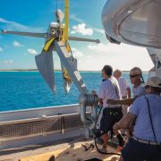
To ensure that large yachts can safely moor in Conception Island National Park without damaging coral, the Bahamas National Trust (BNT) installed three moorings in West Bay. The outermost mooring is a 3,000-pound Navy Danforth-type anchor with 90′ of 11/8″ chain and a 2″ nylon pennant for vessels up to 200 feet LOA. The other two moorings are 1,000-pound Navy stockless anchors with 90′ of 11/8″ chain and 11⁄4″ nylon pennants for vessels up to 150 feet LOA. All moorings have large red buoys and small red pickup buoys. Vessels will need to run their own lines through the large thimbles on the ends of the pennants.
These moorings and their installation and maintenance are the generous gift of Mr. and Mrs. Thomas Bagwell, longtime annual visitors and advocates of Conception Island. Jim Holman, Captain of the Bagwells’ 152-foot yacht CHANTAL MA VIE, and his crew made a special trip to Conception Island to set the moorings with a representative of BNT. Yachts are encouraged to use the moorings but to vacate mooring #1 if CHANTAL MA VIE arrives in Conception Island. GPS coordinates of the moorings:
#1 (3,000 lbs.): 23-51.091N/75-07.644W
#2 (1,000 lbs.): 23-51.109N/75-07.382W
#3 (1,000 lbs.): 23-51.099N/75-07.307W
[photomosaic ids=”5909,5910,5911,5912″ orderby=”rand”]
Bahamas Fisheries Regulations
Over the years there have been changes to Bahamian fisheries regulations but not as many changes as in unfounded rumors. Upon entering The Bahamas all foreign vessels should get a free fishing permit from Bahamian Customs. Customs should provide a copy of current regulations, but they usually do not have copies on hand. We recommend that you get the free fishrules app or go to breef.org for the latest fisheries regulations.
Fishrulesapp.com
This exciting free app is now available for Androids and iPhones. It provides fisheries regulations for the SoutheastU.S., the Gulf of Mexico and The Bahamas. This app also includes fishing guides and by using the GPS in your phone will tell you if you are in a marine protected area.
U.S., the Gulf of Mexico and The Bahamas. This app also includes fishing guides and by using the GPS in your phone will tell you if you are in a marine protected area.
The bag limits for foreign vessels are generous, so the penalty for exceeding the limits can be severe. Remember that the fisheries resources belong to the citizens of The Bahamas who work hard to ensure they maintain sustainable fisheries. Do not exceed the bag limits!
The current limits for foreign vessels with fisheries permits:
• Migratory species such as kingfish, dolphin (mahi mahi), tuna, and wahoo: 18 fish total per vessel at any time
• Conch: 6 per vessel at any time
• Crawfish (spiny lobster): 10 per vessel at any time
• Demersal species (grouper, snapper, etc.) 60 pounds or 20 fish per vessel at any time. The minimum size for grouper is 3 pounds.
• There is a total ban on sea turtles and sharks. All bonefish must be released in good condition.
• The closed season for Nassau Grouper is December, January and February and may be extended if necessary.
Bay Street Marina, Nassau
The Bay Street Marina is a major upgrade to yacht facilities and Nassau’s waterfront. Located just west of the western Paradise Island Bridge, the Bay Street Marina is a protected, full-service marina that is well managed and reasonably priced. There is 24-hour security with cameras, locked gates at the entry of each dock, and a guard dog at night.
The marina has 82 slips and can accommodate vessels up to 200′ with a 12′ draft. Marina Manager Peter Maury and Assistant Dockmaster Jacqueline Callender have many years of experience. The marina is located in front of the Green Parrot, the Harbourfront Lounge, and Luciano’s of Chicago— three restaurants that offer a wonderful variety. Luciano’s is one of the best restaurants in Nassau, but if you aren’t careful eating out may cost more than your dockage.
Also enjoy the free shuttle to Solomon’s Fresh Market to stock up on fresh food and supplies. Expect to pay $2.50 per foot or less depending on your length of stay. baystreetmarina.com
Mann Island, North Eleuthera
Brilanders have long used Mann Island—a beautiful, uninhabited cay just north of Harbour Island—for picnics and camping on holidays, especially in the summer. The southern beach is well protected and perfect for couples or families with children.
Recently the southern third of the island was donated to the Bahamas National Trust (BNT) and has become a national park. The BNT has cut footpaths through the bush for better access to the interior and ocean side. Few yachts anchor near Mann Island, but if you are careful there are several sheltered places to anchor in eight feet over a sandy bottom. Mann can be a wonderful day trip or an anchorage that offers a quiet respite from the hustle, constant wake and expense of Harbour Island.
By Stephen Connett, Southern Boating February 2015