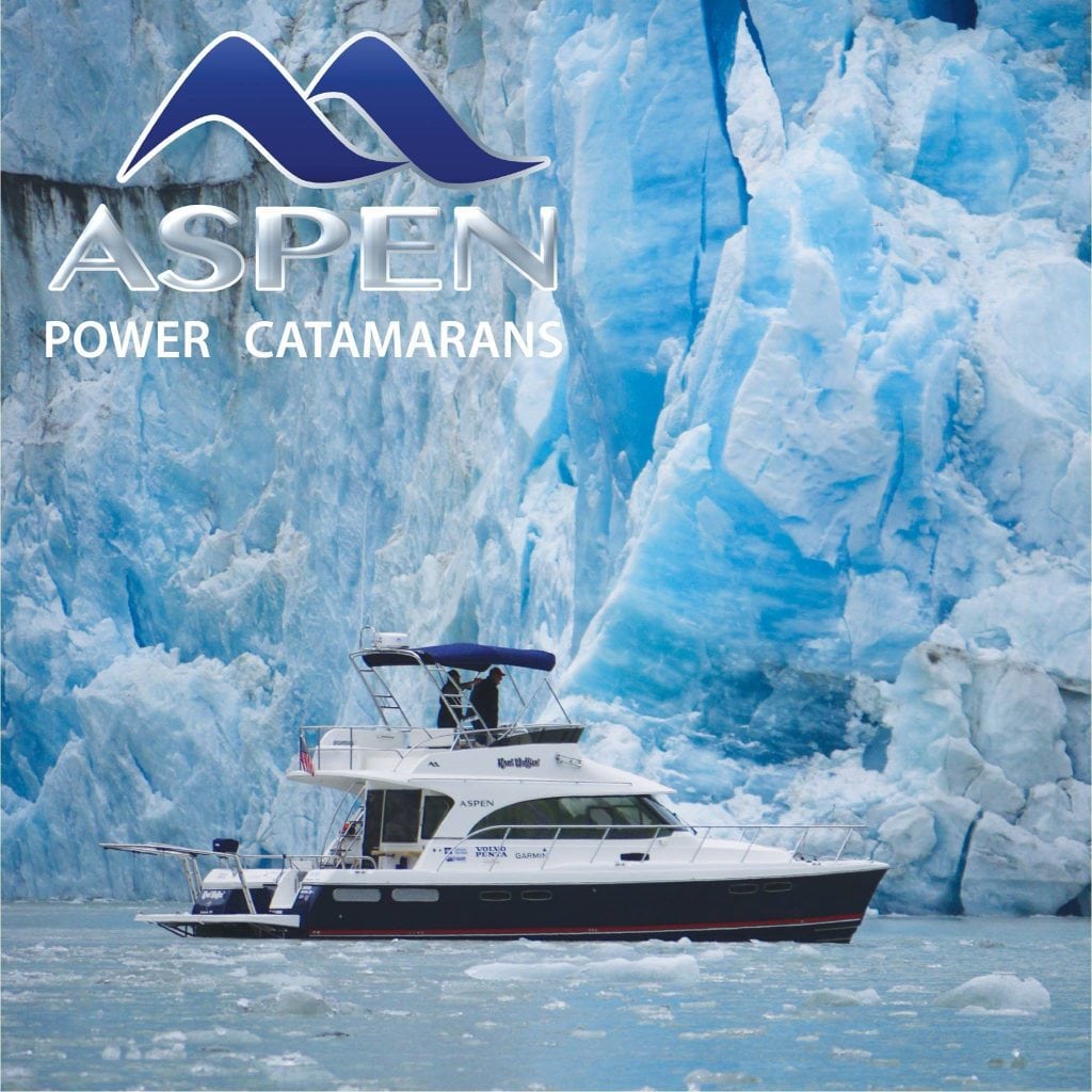
From Washington to DC: The 10,000 Mile Tour

The Jenkins gave a whole new meaning to “taking delivery” when they took their new Aspen Powercat from Washington State to the Chesapeake Bay with a 10,000 Mile Tour.

There’s nothing like stepping aboard your new boat. The imagination runs wild with visions of being anchored in a quiet, glassy cove or heading out on a day trip with the family. David and Sue Ellen Jenkins have shared similar moments on previous boats but wanted one that would take them farther. They did just that when they took delivery of their new Aspen Power Catamarans C120 directly from the factory in northwest Washington State and began a 10,000 mile adventure back to their home on the Chesapeake Bay.

From One Adventurer to Another

Larry Graf, founder and designer of Aspen Power Catamarans, enjoys proving the capabilities of his catamarans (including his previous Glacier Bay boats) on the open ocean. It was through these adventures that he developed a revolutionary hull design and drive system.

The Aspen catamaran hulls are asymmetrical. The starboard hull is 35 percent larger to accommodate the one engine that powers the vessel and includes the only shaft, prop and keel. The result is that it reduces overall drag by 20 percent compared to twin-engine cats. The patented Power Proa Hull is designed to compensate for the thrust and torque of the one engine to keep the boat on a straight track. Because of the reduced drag, fuel efficiency increases by as much as 70 percent over monohulls, and the design has 78 percent more roll stability.

Jenkins and his wife were joined by his brother-in-law, Capt. Blake Eder, who is a delivery captain in North Carolina. They were looking for a boat that had a stable platform and provided comfortable accommodations for long voyages but that could handle the Chesapeake Bay chop. Of course, it needed to have a good-looking profile on the water. Jenkins was intrigued with the Aspen design and headed to Seattle for a sea trial.

Seattle’s car and passenger ferries provided large wakes to test the boat’s stability. “The ferries were going at a pretty good clip. We were cutting right behind [them] to see what it’s going to do in the wakes,” says Jenkins. “There was none of this bouncing; we’d even go to the side of the wake to see how much roll there was, and so judging from that, before I bought the boat, I thought this is really what I want.”

Explaining how the Chesapeake can knock a boat around and everyone in it, Jenkins says, “You don’t have any of that with this boat. It just cuts through it like a knife…After the test drive, I was sold that this boat met my criteria.”

On Tour

Jenkins, Eder, and Graf came up with the 10,000 Mile Tour idea that made the delivery to Maryland an adventure and provided the trip of a lifetime to those farther places. It also provided Graf and Aspen Catamarans a chance to promote the new C120 when the Jenkins family needed to be home.

Knot Wafflen’ (named for Jenkin’s former Carbon Golden Malted waffle business) began with a shakedown cruise through the San Juan Islands before heading north to Alaska. As the crew cruised their way to Glacier Bay, they learned how the boat handled. They worked out all the kinks during the first 2,100 nautical miles of their adventure.

The Gulf of California, including Cabo San Lucas and La Paz, Mexico, was another cruising ground on their list. Jenkins and Eder sailed the boat along the Pacific Coast and around the Baja Peninsula. After their Baja cruise, the owners went back home for business, and Graf stepped aboard to continue the voyage. Graf motored Knot Wafflen’ over to Mexico’s mainland and put it on a truck to Galveston, Texas. From there he sailed over to Lake Pontchartrain in New Orleans, Louisiana, where the Jenkins family met the boat and continued the delivery.

Florida

Nasty weather with strong winds prevented Knot Wafflen’ from traveling around the Dry Tortugas and the Florida Keys. This gave Jenkins and Eder with an interesting alternative to get to Florida’s east coast— through the Lake Okeechobee Waterway. They motored from Fort Myers up the Caloosahatchee River through three locks. Lake Okeechobee is a 35-mile, shallow water crossing, and they traveled alone. “No one else was going to cross the lake but us because the wind was coming from the east; it was dead on our nose,” says Jenkins. “The waves were pushing all the way across the lake and building up because it’s shallow. People would have been pounding their way across having to fight that wind.”

(There is a perimeter canal that boats can take if necessary.) “We just powered up and shot across the tops of the waves. The best way I can describe it is like if you’re in a flats boat and you get up on the [waves] and about the only thing that’s in the water is the prop. That’s exactly what happens with this boat when the waves are close together.”

Back Home

Adventures like these last a lifetime, and in reflection, Jenkins shared three thoughts. For one, he felt the journey took too long and didn’t think he’d do it again. “However, I found many places worth returning to,” he says. “We’ll charter in those areas, such as British Columbia, the San Juans or the Sea of Cortez. Everything from Annapolis to New Orleans we can reach in three weeks, weather permitting in the Atlantic and the Gulf.”

Second, he reached his goal of becoming an expert on his own boat. Finally, the boat proved its sea-worthiness. Plus, the boat fit in standard marina slips.

“The bottom line is when we have to move at a good clip to enjoy a destination or to beat some weather or in [case of] an emergency, it can get us there quickly and safely!”

Knot Wafflen’ will be on display at the United States Powerboat Show in Annapolis October 11-14, where you can hear the whole tale.

By Steve Davis, Southern Boating August 2018

Photos courtesy of Aspen Power Catamarans and David Jenkins

Okeechobee Waterway

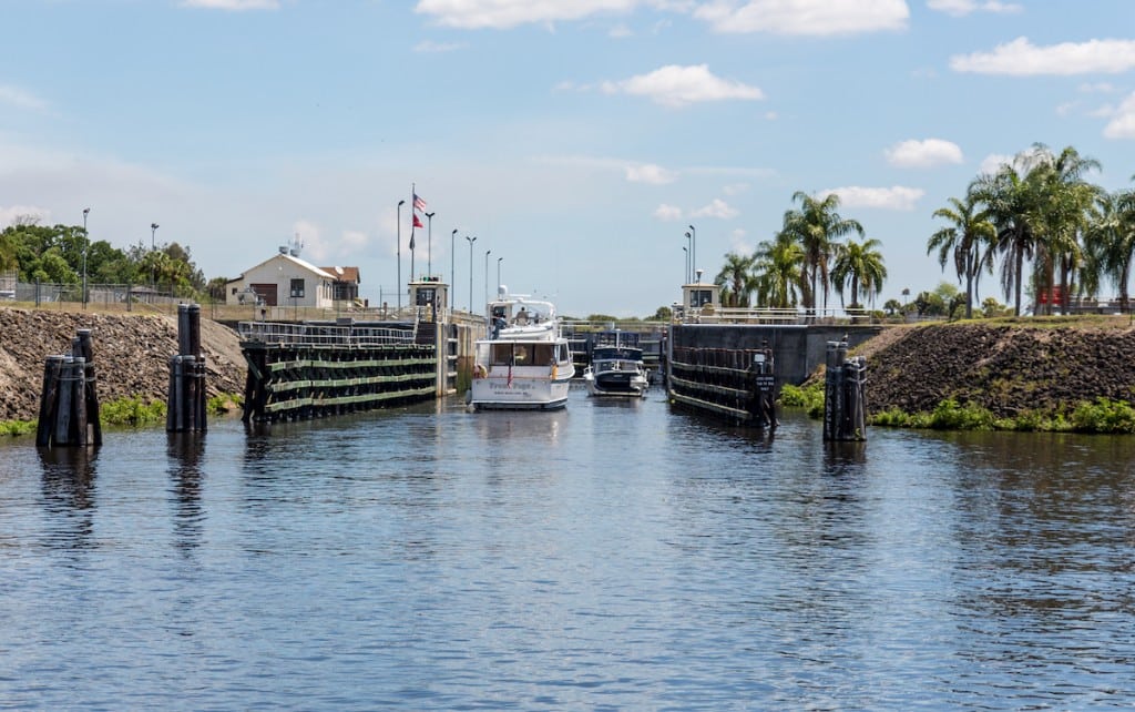
The Okeechobee Waterway: Cruising the water that connects the seas

Florida is best known to boaters for the water around its edges, which is no wonder with more than 2,000 miles of tidal shoreline open to the sea. But the interior of Florida is almost as wet as its shoreline, with some 30,000 inland lakes covering over 3 million acres.

With all of that water in between and the distance around the state, it didn’t take early residents long to think of connecting the Atlantic and Gulf Coasts by a cross-state waterway. Creating this navigable route was made easier by a huge lake conveniently placed in the southern center of the state—the second-largest lake (behind Lake Michigan) in the contiguous 48 States and the largest contained within a single state. Lake Okeechobee was known to Florida’s Seminole Indians as “Oki Chubi,” which means “Big Water.”

The Waterway’s Origins
In the late 1800s, developers began plans to connect Lake Okeechobee to the headwaters of the Caloosahatchee River. The proposal was to cultivate the land around the lake and create a water-navigable route to the Gulf Coast. The land reclamation program was overwhelmingly successful and opened thousands of acres of rich agricultural property around the lake for settlement. Unfortunately, in the following years, a series of hurricanes exposed those new lake residents to catastrophic flooding and the loss of many lives.

Realizing the need to protect people and property as well as creating a permanent cross-Florida waterway, Florida’s government funded programs to build larger containment dikes around the lake and the “Okeechobee Waterway” as we know it today.

The Route
The waterway was developed by digging two man-made canals—from the headwaters of the Caloosahatchee River on the Gulf Coast and from the St. Lucie River on the East Coast—to Lake Okeechobee. The official length of The Okeechobee Waterway is 156 statute miles or 134.3 nautical miles from its intersection with the Atlantic Intracoastal Waterway in Stuart to the Gulf Intracoastal Waterway in Fort Myers. Due to Lake Okeechobee’s shallow depths of 8 to 12 feet, and only averaging 15 feet above sea level, a direct connection to the sea would drain the lake completely.

To maintain the lake’s depth, three locks were built to raise vessels from sea level on the Gulf Coast to the level of Lake Okeechobee, and two locks lower vessels back down to sea level on the Atlantic Ocean. Two established routes cross the lake. Route 1, which is the “Cross Lake Route,” proceeds from Port Mayaca directly across the southern portion of the lake to the town of Clewiston. Route 2 is referred to as the “Rim Route” and follows the southern shoreline passing the towns of Pahokee and Belle Glade before joining up with Route 1 at Clewiston.

Route 1 offers a faster crossing and carries more depth, while Route 2 allows for a more relaxed and protected route, especially with southerly winds.

Navigation and Lock Handling
The specific elevation change of the water in the locks will vary with the depth of the lake. When the lake and canal water levels are high enough, some of the locks may stay open.

During very low water levels, the St. Lucie and Franklin locks may operate on restricted hours to maintain water depth. The U.S. Army Corps of Engineers (USACE) operates the locks and maintains Lake Okeechobee’s depth.

Adhering to the same rules as the Intracoastal Waterway (ICW), the Okeechobee Waterway is marked off in statute miles and follows the lateral buoy system of keeping red markers or markers with yellow triangles to starboard when traveling from east to west.

Water depth and bridge clearance are the two factors a boater must take into account when planning a crossing. The waterway’s depth varies with the lake level, so consulting the USACE is important for a safe crossing. In addition to the five locks, there are numerous opening and fixed bridges along the way. The lowest fixed bridge at Port Mayaca allows 49 feet of clearance at high water. Boating through the locks is not difficult with proper preparation. The lock walls are concrete, so having enough durable fenders to protect the boat is important.

The lock tenders will instruct boaters on which side of the lock they want the vessel tied. In locks with rising water, the lock tenders will lower fore and aft handling lines to the vessel. The mariner will take one wrap of the lines around cleats on the craft and take up the slack line as the boat rises.

If possible, it’s best not to be the first vessel in a lock with rising water, as that boat takes the most turbulence of the water coming through the opening in the forward lock gate. When a boat is being lowered in a lock, the handling lines are also wrapped once around a cleat, and the line is allowed to play out as the vessel is dropping.

Always wear sturdy gloves with which to handle the lines. On average, 30 minutes should be allowed to transit each lock. Unless operating on restricted hours during low water levels, the locks open on request daily from 7AM until 5PM. The last entrance to a lock is at 4:30PM. A fast boat averaging 20 knots can complete the crossing in about eight hours. A trawler or sailboat would take around 20 hours at 7 knots, making for a leisurely trip with two nights spent on the waterway in the process.

Stops Along the Okeechobee Waterway
Most boaters will stage at a marina in Stuart on the East Coast or in Fort Myers on the Gulf Coast to begin a crossing. There are marinas and municipal town docks conveniently located for the seafarer willing or needing to take multiple days to cross. Communities like Port LaBelle, Moore Haven, Clewiston, and Indiantown are an interesting part of Florida’s history.

These towns and villages give the visiting mariner a real sense of “old Florida,” where hunting and fishing are still an important way of life. Wilderness outfitters provide guided trips through the beauty of this remote area with fishing or hunting expeditions. The Waterway’s inland protection from coastal storms is also creating a growing business for off-season boat storage, with facilities in Stuart, Indiantown and Port LaBelle, some of which offer large storm-rated buildings where a vessel can be kept indoors.

Florida is a fascinatingly diverse state, with coastal communities influenced by the cultures of all its transplanted citizens and visitors. Central Florida, by comparison, still has much of its original culture and character intact. If the majority of your boating has been offshore, cruising the Okeechobee Waterway not only makes for easy passage from one coast to the other, it also provides for an interesting view of historic Florida and the beauty of water in between.

Cruiser Resources

MARINAS EAST OF LAKE OKEECHOBEE
Indiantown Marina, Indiantown
(772) 597-245 • indiantownmarina.com

River Forest Yachting Centers, Stuart
(772) 287-4131 • riverforestyc.com

Sunset Bay Marina & Anchorage, Stuart
(772) 283-9225 • sunsetbaymarinaandanchorage.com

MARINAS WEST OF LAKE OKEECHOBEE
City of Fort Myers Yacht Basin
(239) 321-7080 • cityftmyers.com/381/Yacht-Basin

Legacy Harbour Marina, Fort Myers
(239) 461-0775 • legacyharbourmarina.com

Moore Haven City Docks
(863) 946-0711 • moorehaven.org

River Forest Yachting Centers, Moore Haven
(863) 612-0003 • riverforestyc.com

Roland & Mary Ann Martins
Marina & Resort, Clewiston
(863) 983-3151 •  RolandMartinMarina.com

ATTRACTIONS/GUIDES

Lake Okeechobee Fishing Guide
lakeokeechobeeguide.com

Eaglebay Airboat Rides
okeechobeeairboat.com

Ah-Tah-Thi-Ki Seminole Indian Museum
ahtahthiki.com

BlueSeas’ Okeechobee Waterway Cruising Guide
offshoreblue.com/cruising/okeechobee.php

By Bob Arrington, Southern Boating Magazine July 2017

River Forest Yachting Centers, Stuart, FL

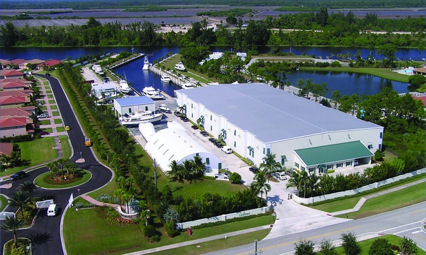
River Forest Yachting Centers provide discriminating boat owners with luxurious, secure, long and short-term storage for boats from 24′ to 90′. Strategically located between the locks on both sides of Lake Okeechobee in protected fresh water basins, RFYC operates facilities in Stuart, Florida (est. 2005) and LaBelle, Florida (est. 2009). The Stuart location offers new customers stabilized land storage with tie-downs and free haul, clock, launch, and pressure wash. The LaBelle location offers Gulf Coast cruisers convenient storage near Fort Myers and is located on the Caloosahatchee River just east of the Ortona Lock.

A safe haven for boats, River Forest Yachting Centers include climate-controlled and non-climate controlled indoor storage coded for 140-mph winds, pristine secure land storage with hurricane grade tie-downs, and concrete wall side-tie dockage. Cruisers are welcome and will be pleased with the clean, peaceful surrounding and friendly staff.

RFYC offers a full complement of repair and maintenance services at both locations. Each facility provides a members-only Hurricane Club® for safe harbor and peace of mind in the event of a storm. RFYC is recommended by insurance carriers to satisfy the requirements of the underwriters for Florida boat storage during hurricane season.

LaBelle’s location offers a new floating dock, and Stuart boasts new secure stabilized land storage for 20 additional boats. New storage buildings are on the horizon for 2016 at both locations. RFYC is committed to continually growing and expanding their services to enhance their customer’s satisfaction and commitment to excellence.

[photomosaic ids=”5931,5932″]

Stuart, Florida Specifications:
Climate-controlled and non climate-controlled storage buildings
Indoor Storage for up to 70 vessels in 45,000 sq. ft.
24-hour security system
100 amp electricity available for battery charging
132,000 lbs. ASCOM Marine Lift
100,000 lbs. ABI Self-Propelled Hydraulic Transporter
Indoor Storage Building
In-Water Storage in Freshwater Basin
2 acre freshwater (barnacle-free) basin with 1400′ of deep water broadside dockage
Hurricane protected dockage with internal crosstie cleats for hurricane tie-down
Covered Service & Maintenance Building

LaBelle, Florida Specifications:
Climate-controlled and non climate-controlled storage buildings
Indoor Storage for up to 150 vessels in over 100,000 sq.ft.
100 amp electricity available for battery charging
164,000 lbs. ASCOM Marine Lift
132,000 lbs. ABI Self-Propelled Hydraulic Transporter
66,000 lbs. ABI Self-Propelled Hydraulic Transporter
In-Water Storage
2 acre freshwater (barnacle-free) basin with 900′ of deep water broadside dockage
Hurricane protected dockage available with internal crosstie cleats for hurricane tie-down
Storage lots available on 2 acre of concrete pad for long term or hurricane season storage
Covered Service & Maintenance Building
Protected service area for vessels undergoing any of the many maintenance and detailing services offered by RFYC
Clubhouse
Helipad

Contact
Tracy L. Campbell
Director of Client Services
(772) 287-4131
riverforestyc.com

RFYC STUART
9150 SW Pennsylvania Ave.
Stuart, Florida 34997
(772) 287-4131
Hours: M-F 8AM-5PM

RFYC LABELLE
1992 Williams Road
Moore Haven, Florida 33471
(863) 612-0003
Hours: M-F 8AM-5PM

By Christine Carpenter, Southern Exposure

Exit mobile version