

Navionics celebrates 30 years in business this year, but instead of resting on its laurels, the company has taken steps to incorporate bold new innovations into its navigation technology. Gone are the days of navigating via paper charts, and if mapping companies like Navionics have their way, soon we’ll navigate using smartphones and tablets, which will not only sync with plotters but also transmit updated chart data continuously in real time to make boating safer for everyone.
At the Miami International Boat Show in February, Navionics founder and president Giuseppe Carnevali discussed its crowd-sourcing initiative that seeks to improve ICW chart data from Maine to Florida. The ICW’s bottom contours can shift as a result of hurricane seasons, strong tidal fluctuations, changing currents, and other acts of nature, as well as manmade changes such as construction and dredging. To address inaccuracies, Navionics conducts its own surveys with privately funded teams, and leverages its customers with a combination of two technologies: SonarCharts and Community Edits.
Navionics SonarCharts allow mariners to record and share their sonar logs while cruising, fishing or just motoring around. Collected data is uploaded to a massive repository of charting data where complex algorithms select the most reliable soundings and scrub them against other data collected in the area, producing an up-to-date chart. In addition, Navionics’ app allows users to contribute improvements using Community Edits. Stumble upon a wreck, a spill or some other hazard not currently available on your chart, and with a few taps you can add a marker and notes to instantly share it with the entire Navionics community. These edits also become part of the overall data collection effort, which should result in enhanced content and peace of mind for recreational boat owners, the company claims.
“We have a community of customers numbering around 3 million,” says Carnevali. “About 100,000 of them are actively contributing to Community Edits. That’s a lot, especially if you consider that Wikipedia, for example, has something like 0.01 percent of users contributing to the content. Our participation is orders of magnitude higher.”
Thanks to the input of this community, Navionics’ ICW charts will feature up-to-date commanding depths, vertical and horizontal bridge clearances, accurate speed limits, vertical overhead cable clearance, updated coastlines, and improved shoal presentation, plus daily improvements to bottom contours, suggested routes and the Magenta line. And with the National Oceanic and Atmospheric Association (NOAA) ceasing to produce paper charts as of April 2014, Navionics hopes to lead a mapping revolution both for and by the boat owner.
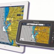
In some countries electronic charts are already considered legal replacements for paper charts, and apps are eclipsing the web in terms of mobile data usage, so bringing the two technologies together makes a lot of sense. Using the company’s GoFree Wireless protocol, the revamped Navionics Boating app interfaces wirelessly with Raymarine and Navico-brand chartplotters (Simrad, Lowrance, B&G) and can download new charts that blend with the user’s existing chart collection, thereby ensuring all chart data is as current as possible. It’s useful off the water as well—routes, tracks and waypoints remain available on the user’s mobile device even after being downloaded to the plotter.
According to Carnevali, in 2013 Navionics’ app was accessed about 40 million times. This high level of usage led Navionics to believe that mobile apps represent the latest “disruptive technology” that stands to revolutionize the way boating enthusiasts enjoy their time on and off the water. But Carnevali stresses that the medium cannot be the message—that content must evolve to take full advantage of modern devices, and not merely be repackaged.

“When a new technology becomes available—a disruptive technology—people tend to do, for some time, the same old thing but on the new technology,” he explains. “When TV first came out, it was basically radio plus an image. It wasn’t really TV the way we know it now. When smartphones first came out they did things the same way it was being done on the web. Now with apps, [smartphones] are evolving into something very different. The same has been happening with nautical charts. From paper to raster to vector to mobile. The world is changing. It makes me happy that we initiated that.”
Download Navionics’ new app for free to view the worldwide chart coverage available for purchase from the iTunes App Store and Google Play for Apple and Android mobile devices. Boat owners who already own the previous version, Marine & Lakes, will get all the new features of Navionics Boating for free the next time they update their app. navionics.com
By Brian Hartz, Southern Boating May 2014