
Every boater needs to know the surface condition of the water they are traversing. This condition is referred to as the “seas” and is the result of both waves and swells.
But what’s really going on here and what’s a wave?
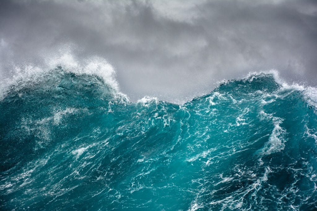
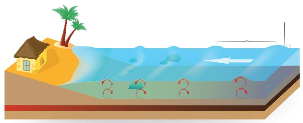
What’s a wave? Time for some physics. A wave is a packet of energy that moves away from its source. Waves of energy are emitted from the sun, move through the vacuum of space, reach the earth, and heat it. If these waves of energy are moving through some substance, a disturbance is created. Waves on the ocean are packets of energy moving along and give the illusion that the water itself is moving. In reality, it’s the wave energy that moves and causes the water level to progressively rise and fall as the wave passes, but the water actually moves in a circle with little forward motion.
The most common cause of typical surface waves is the wind. Friction between the water surface and the air just above it allows some of the wind energy to transfer down into the water. Although we typically only see the wave on the surface, the disturbance and water movement extend downward generally to half of the wave’s wavelength.
Geological Disturbances
In previous articles, I’ve discussed storm surges with hurricanes, tsunamis due to geological influences, and meteotsunamis associated with atmospheric pressure changes. In these cases, the sea level is actually elevated locally when the disturbance reaches the coast. When an oceanic wave approaches the coast, its structure changes. The bottom of the wave begins to slow due to frictional effects with the increasingly shallow ocean floor.
As the lower part of the wave slows, water converges, and compression forces water upward, building the height of the wave. With the top of the wave outracing the bottom, eventually, the wave becomes unstable and breaks toward the shoreline. The most significant aspect of a wave is its height, the distance from the trough to the crest. A wave’s size depends on wind speed, wind duration and the area over which the wind is blowing (the fetch). This will determine the total amount of energy transferred to the water.
Large waves are only produced when all three factors combine: strong winds, long duration and a long fetch over open water. Even under similar conditions, waves of varying heights are generated due to wave interactions. In standard descriptions of current or forecast conditions, the term “significant wave height” is used. By definition, this is the average height of the highest third of the waves. In my article on rogue waves, I noted, and official forecasts warn, that individual waves can be twice the size of the significant wave height.
 Cascading Effects

Under extreme conditions, even larger waves can occur. There are other aspects of waves to note. The wave length is the distance between successive wave crests. The wave period, usually given in seconds, is the time it takes for successive waves to reach the same point. Swell waves, or just swell, refers to waves originally produced by wind that are now out of the generating wind field. They are more consistent and have a longer period than wind waves. These self-maintaining waves can propagate across the ocean for many miles and can move in directions that differ from the current wind field.
Reports on ocean conditions often include the swell direction, the direction from which the swells are coming. Don’t underestimate swell waves. In early March 2018, a powerful winter storm developed off the New England coast. Hurricane-force winds generated 40-foot seas over the North Atlantic. Swells generated by the storm propagated southward toward the Greater Antilles, more than 1,500 miles to the south. Buoys off the north coast of Puerto Rico recorded swell wave heights of 15-20 feet, record or near-record wave heights for March. Wave heights increased to as much as 30 feet and impacted the north coasts of Puerto Rico and the U.S.V.I. Widespread coastal flooding and beach erosion occurred.
A History of Waves
An interesting combination of wind speed and sea condition is the Beaufort Scale, named for Sir Francis Beaufort, an admiral in the British Navy. His original scale from 1805 related wind speed to sea condition and the ability to predict wind speed from sea condition and vice versa. For example, calm winds were associated with a “smooth and mirror-like” sea surface. On the other extreme, hurricane-force winds of 64 knots or greater were associated with “waves over 45 feet, a completely white sea due to spray and greatly reduced visibility.”
Current sea conditions are always available through the National Weather Service (NWS). You can also check out the National Data Buoy Center. Some buoys report wave height, wave period and wave direction. The NWS also provides marine forecasts that include sea conditions out to five days. There are numerical models that also utilize forecast weather conditions to predict wave heights. The Nearshore Marine Forecast or Coastal Waters Forecast covers a specific given area from the coastline out to 20 nm.
This is followed by an Offshore Marine Forecast or Offshore Waters Forecast that goes out from 20 to 60 nm, and finally the High Seas Forecasts for farther reaches. These forecasts will include wind wave and/or swell, or a combined seas or seas wave height along with the wave period for the near shore.
By Ed Brotak, Southern Boating


