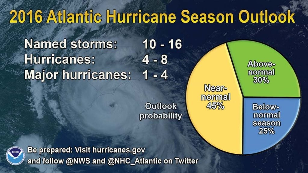
Hurricane season is once again upon us and technically runs from June 1st through November 30th. NOAA’s Climate Prediction Center expects a near-normal season, however, they also warn that current and changing climate signals make predicting this season exceptionally challenging. History shows that our currently dissipating El Niño patterns could potentially lead to the hurricane-friendly conditions of La Niña. “This is a more challenging hurricane season outlook than most because it’s difficult to determine whether there will be reinforcing or competing climate influences on tropical storm development,” explains NOAA’s Climate Prediction Center lead seasonal hurricane forecaster, Gerry Bell, Ph.D. “However, a near-normal prediction for this season suggests we could see more hurricane activity than we’ve seen in the last three years, which were below normal.
Here’s the breakdown of NOAA’s 2016 predictions:
–70 percent likelihood of 10-16 named storms (winds of 39 mph or higher)
–Of the named storms, 4-8 could become hurricanes (winds of 74 mph or higher)
–Of the hurricanes, 1-4 could become major hurricanes (Category 3, 4 or 5, with winds of 111 mph and higher)
One thing is true: It’s been more than 10 years since a hurricane has hit the southeast seaboard, so any 2016 activity could cause more damage than anticipated since communities may not be prepared for a normal season. Many southeast residences seem to have some kind of “hurricane amnesia” due to the lack of hurricanes for so many years, which is particularly concerning. According to NPR member station WJCT reporter Ryan Benk, “A [AAA] survey shows nearly half of Floridians are not actively preparing for hurricanes. And less than a quarter said they won’t evacuate, even if told to.” Those residing along or close to the coast, a population that has grown by nearly 50 percent in the last 40 years, are especially vulnerable to risks posed by hurricanes and storms.
And it’s even more challenging to forecast this season’s progression and potential impact because of La Niña’s unpredictable behavior. “There’s even more information now strongly suggesting that there’s at least a 75-80 percent chance that we will go into a La Niña pattern,” says AccuWeather Atlantic hurricane expert, Dan Kottlowski. “Historically, some hurricane seasons that have followed a transition from El Niño to La Niña have been very active. It’s possible we could flip from one extreme to the other, from below-normal seasons the past three years to an above-normal year in 2016.” If La Niña takes hold this month, it would most likely last through December.
Changes in global atmospheric circulation patterns supplement La Niña and are responsible for weather extremes in certain spots around the world. These weather extremes are routinely contrary to those associated with El Niño. Steve Graham of NASA characterizes La Niña: “These patterns result from colder than normal ocean temperatures inhibiting the formation of rain-producing clouds over the eastern equatorial Pacific region while at the same time enhancing rainfall over the western equatorial Pacific region (Indonesia, Malaysia and northern Australia). These patterns affect the position and intensity (weakening) of jet streams and the behavior of storms outside of the tropics in both the Northern and Southern hemispheres.”
By Alana Schindel, Southern Boating Magazine
August 2016


