


“The Dead Zone” may sound like the title to an old horror movie, but these barren ocean wastelands are very real. Officially referred to as “hypoxia”, dead zones are areas of the ocean that are devoid, or nearly devoid, of aquatic life. Creatures that could move away have done so, while others have died. The problem is a reduced level of life-sustaining oxygen in the water. Some dead zones occur naturally. However, the worst of them today are the result of man’s activities.
The main cause of man-made dead zones is nutrient pollution called “eutrophication” by scientists. Nutrients such as nitrogen and phosphorous are vital to plants and are major ingredients in many fertilizers. If excessive amounts of these elements find their way into bodies of water—fresh or salt water—they will spur the overgrowth of algae and phytoplankton (microalgae). The initial algal bloom can block sunlight from reaching the
waters below. Plant life at lower levels can’t produce oxygen thus beginning the hypoxia process. When the algae die and sink it will decompose, using up more oxygen in the lower reaches. There is not enough oxygen left to support normal aquatic life and the result is a dead zone.
Eutrophication has steadily increased in recent years due to industrial activities, the effluent from wastewater treatment and, in particular, intensive agricultural practices. It is estimated that human activities produce twice as much nitrogen and phosphorous as natural sources. The extensive use of animal manure and commercial fertilizers to
increase agricultural production is a major source of nutrient contamination in water that has drained off farmlands.
Dead zones typically develop during the summer months. Obviously, during the growing
season, more fertilizer, etc. is being applied to crops. Also, we get temperature stratification in bodies of water. Upper layers are heated by the intense sunlight. The
warmer water is less dense, lighter and there is little vertical mixing with the colder, denser water below. If decomposing algae uses up oxygen in the bottom waters, it can’t be replenished from above. Dead zones normally last several months until fall weather systems promote mixing.
It’s important to note that although dead zones and the red tide can be linked to a similar cause—nutrient pollution— they are not the same. The red tide is also an excessive algae
bloom, but in this case, an actual toxin is released into the water by the algae. This can kill fish, make shellfish dangerous to eat and even make people sick.


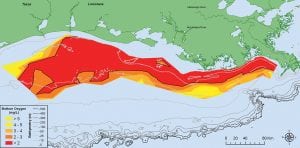
Dead zones exist around the world; more than 100 of them have been documented. In the U.S. alone, the Great Lakes, the East Coast and, particularly, the Gulf of Mexico all have dead zones. The northern Gulf, the region of the Louisiana/ Texas continental shelf, has an enormous dead zone in the summer. This is critical since the northern Gulf encompasses almost half of the nation’s coastal wetlands. Commercial and recreational fishing in the region, including the shrimp industry, generate $3 billion annually.
The Gulf of Mexico Dead Zone was first discovered in August 1972. Scientists found oxygen-depleted bottom waters off the Louisiana coast at depths ranging from 30 to 70 feet. Normally, oxygen levels identify about 7 parts per million (ppm), but they had dropped to 2 ppm or less. It is believed that even though there was some oxygen depletion noted before this, conditions became much worse starting in the 1970s. Since
1985, the dead zone has been measured and mapped to show its size, and the actual size of the dead zone varies from one year to the next. This past summer, the Gulf of Mexico dead zone grew to 8,776 square miles, the size of New Jersey. Not only was this the largest it’s ever been since measurements began, but the Gulf of Mexico now had the largest dead zone in the world.
Why is this occurring here? The Mississippi River flows into the Gulf of Mexico along the Louisiana coast. The Mississippi River watershed encompasses 1.2 million square miles or 41 percent of the continental U.S., and it even extends into Canada. Much of this land is devoted to agriculture.
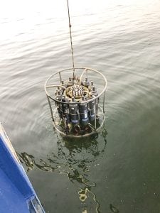
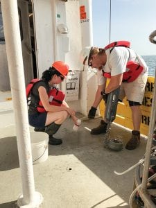
There is no way to remotely detect dead zones. Satellite imagery can show massive algal and phytoplankton blooms near the ocean surface, which are the precursor of hypoxic areas. But to check what’s going on underneath the surface, samples of water must be taken. One of the main groups dealing with this problem is the Louisiana Universities Marine Consortium (LUMCON). They have a Hypoxia Research Team that monitors conditions in the northern Gulf utilizing a marine laboratory (the DeFelice Marine Center) and a fleet of research vessels.
On the Federal side, the National Centers for Coastal Ocean Science not only provide money for research but also produce an annual forecast in June of the expected maximum size of the Gulf dead zone. Computer models use runoff projections for the Mississippi River based on antecedent precipitation. To help alleviate this problem, the EPA-formed Mississippi River/ Gulf of Mexico Hypoxia Task Force has set a goal size of under 2,000 square miles for the dead zone by 2035. And though some reduction in nutrient pollution
has been accomplished, it is estimated that a further reduction of 60 percent would be necessary to achieve the set goal.
By Ed Brotak, Southern Boating January 2017