

NOAA’s GOES-16 is changing the face of traditional forecasting.
The first of the next generation of Geostationary Operational Environmental Satellites (GOES) was successfully launched from Cape Canaveral on November 19, 2016. Although the satellite was referred to as GOES-R during the development stage, it was rechristened GOES-16 upon achieving earth orbit. It had been nearly seven years since the last of the older satellites, GOES-15, was launched.
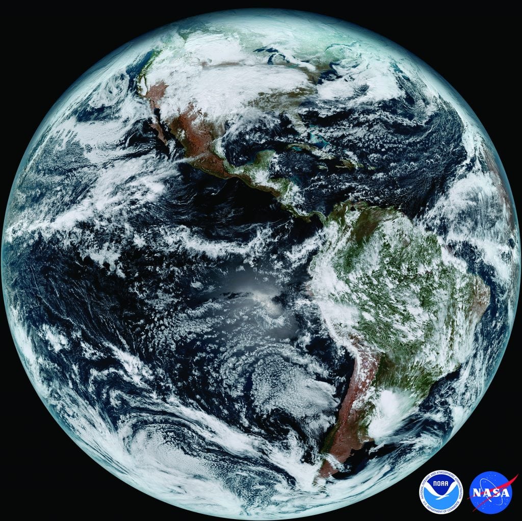
The new satellites represent a major advancement in weather monitoring. Compared with the older satellites still in use, GOES-16 has three times the number of observing “channels”, four times greater image resolution and is five times faster. The satellite can generate 34 different products, and another 31 products are planned for the future.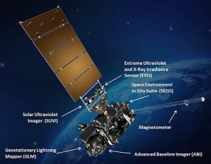
To give you a full overview of its capabilities, this satellite can do a full disc scan of the Western Hemisphere every 15 minutes, scan the continental U.S. every 5 minutes and focus in on areas of severe or interesting weather every 30 to 60 seconds; all of this happens simultaneously. GOES-16 is also equipped with the first satellite-borne lightning detection system known as the Geostationary Lightning Mapper (GLM), which means that lightning can now be tracked continuously from space.
Currently, GOES-16 is undergoing testing and is planned to become fully operational in November 2017. The next satellite in the new series, GOES-S, is scheduled to launch in the summer of 2018. The projected operational lifetime of the new satellites is through 2036.
With increased sensor ability, we can analyze the atmosphere from top to bottom and trace atmospheric moisture, which is responsible for clouds and all precipitation and see how it moves. For marine interests, satellites provide weather information over vast ocean areas where there wasn’t any previously. Satellite data improves the accuracy of weather forecasts for everyone.
One of the biggest advances in meteorology due to weather satellites is the ability to detect and track tropical cyclones. Before 1960, scientists had to rely on boat or aircraft encounters with these storms to locate and determine the strength of the system. Even major hurricanes would sometimes avoid detection if they were in a seldom-visited section of the ocean; fast-moving storms could strike with little advance warning. This all changed with the advent of weather satellites constantly monitoring the tropical oceans. For example, GOES-16 can scan a tropical cyclone and use cloud top temperature changes and cloud structure to estimate the strength of the storm. It can monitor changes over time to determine if the storm is getting stronger.
With its high-resolution imagery, GOES-16 can provide great detail about individual thunderstorms for meteorologists to study further. Because images are available every 30 to 60 seconds, the development of the storm can be closely monitored and timely warnings can be issued if necessary. A lightning detector can show if the storm is becoming more or less active. This should mean better forecasts of the severe weather conditions that often accompany these storms.
The capabilities of GOES-16 are amazing. It can estimate rainfall rates at the surface, and future products will forecast the probability of rain occurring and how much can be expected. It can determine land and sea surface temperatures. Snow depth will be estimated from space. River flooding can be monitored closely in real time. Particularly for marine interests, GOES-16 will be able to closely monitor the direction and speed of ocean currents. Besides the weather on earth, GOES-16 will also monitor solar activity and “weather in space” that can greatly affect us. Improved instrumentation will closely track geomagnetic storms and flares on the sun that can disrupt communications and energy transmission on earth. It can also better determine radiation hazards above the atmosphere where our astronauts work.
MORE INFORMATION:
By Ed Brotak Southern Boating May 2017


